Kitesurfing Weather Conditions: How to Read the Sky
Tips to assess if the weather is fit for our incoming kite session.
Imagine yourself enjoying a kitesurfing session when the weather suddenly changes, and you are not sure if a storm is coming, the wind is changing, or it's just some clouds that will not impact any of your kitesurfing conditions. Obviously, you will not want to get out just to check the weather online, on windy, windfinder or windguru, so it's pretty helpful to recognize the various weather patterns by observing what's around us.
Kitesurfing, like all wind-based sports, is influenced by weather conditions. So it is always advisable to have a good kitesurfing wind forecast at hand, but when we are on a beach, it is advisable not only to understand the optimal kitesurfing conditions but also to know when to stay away from the water. Let's see how we can do so by knowing how the wind is generated and which conditions we can encounter during our kitesurfing session.
The wind is basically moving air: the cause of this motion is the difference of
pressure
in various areas of the planet, which is a direct consequence of varying temperatures due to the different
intensities of the solar radiation on Earth's surface.
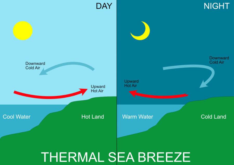
The sun is the wind engine and can generate it at a planetary scale or locally due to specific geographical
configurations. We often talk about 'thermal' winds in this second case.
When the situation is steady: constant wind, no air temperature variations, and clear sky, we can enjoy our session confident the conditions will remain reasonably unchanged, but when we notice changes in the air temperature or in the cloud patterns in the sky, we should pay attention to the developments.
It is good to have a basic idea about how to read the sky by its appearance, temperature, and humidity to forecast the weather, even without any technology or weather maps, or internet.
The movement of cold or warm air fronts is usually one of the major factors that influence weather condition changes. There are basically two scenarios: a warm front coming after a cold one or vice-versa. To understand what happens, we have to keep in mind these three basic facts:
- When cold and warm air move against each other, cold air slides under warm air due to the difference in density; as a result, warm air is pushed up in the atmosphere.
- Warm air generally is way more humid.
- As warm air moves higher and higher, it starts to cool down, producing clouds from its humidity.
1. The first situation: a warm front approaching a cold front.
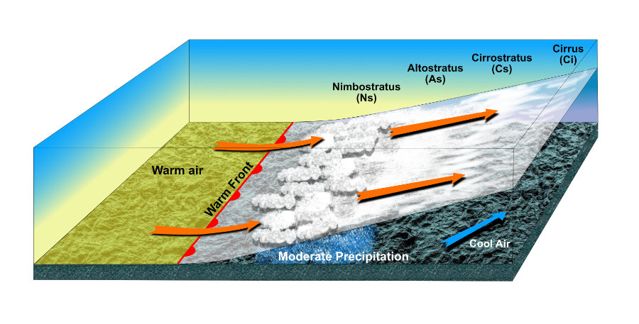
As shown in the picture, when a warm front comes against a cold one, due to the difference in density, the warm air, full of humidity, starts to slide over the cold air, and this movement produces slow condensation of water vapor that starts to create clouds. Notice that the clouds, in this case, anticipate the warm front arrival at ground level.
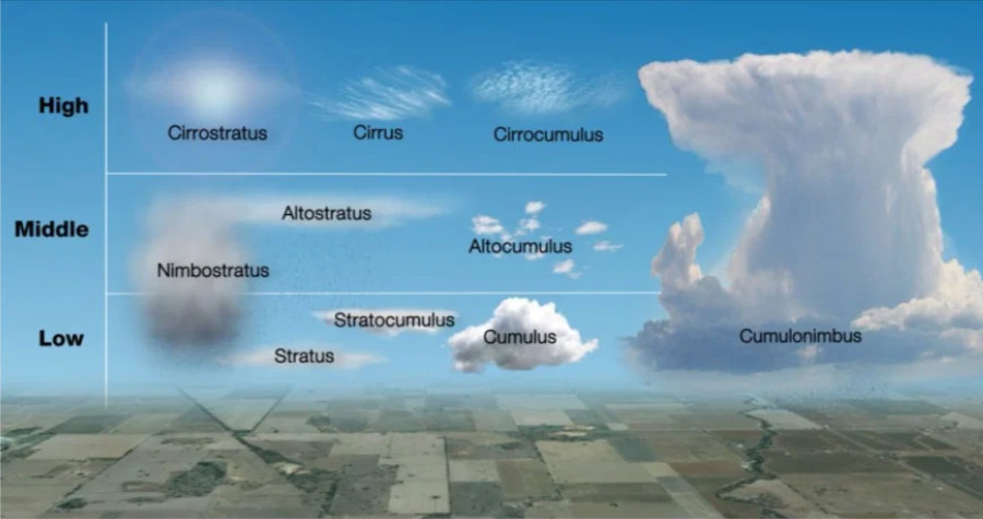
The clouds that appear first are high Cirrus, followed by Cirrusstratus (at lower altitudes), then the thicker Altostratus (at even lower altitudes, appearing closer to the border of cold and warm air), followed by the Nimbustratus ones, which normally bring rain (nimbus: rain in Latin). This sequence is usually pretty slow, and you can see the first Cirrus clouds even 36 hours before the rain by the Nimbustratus clouds starts.
In this situation we normally see the following changes in the area:
Meteorological sequence of an entering warm front:
|
|
Approaching front
|
Front passing over
|
Inside the warm front
|
|
Wind
|
Reinforces and changes direction
|
Abrupt changes
|
Constant direction
|
|
Clouds
|
Sequence of Cirrus, Cirrostratus,
Altostratus, Nimbostratus and Stratus
|
Nimbostratus
|
Stratus and Stratocumulus
|
|
Rain
|
Heavy and continuous
|
Light or even stops
|
Occasional or light rain
|
|
Visibility
|
Gets worse as the rain becomes stronger
|
Bad
|
Limited with occasional fog formations
|
2. The second situation consists of a cold front overcoming a warm one:
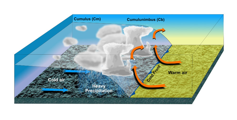
This situation normally leads to much more dramatic weather conditions. The overcoming cold front
pushes the highly humid warm air to higher altitudes very fast, causing massive condensation and
convective wind currents. This effect produces the most dangerous cloud formation, the
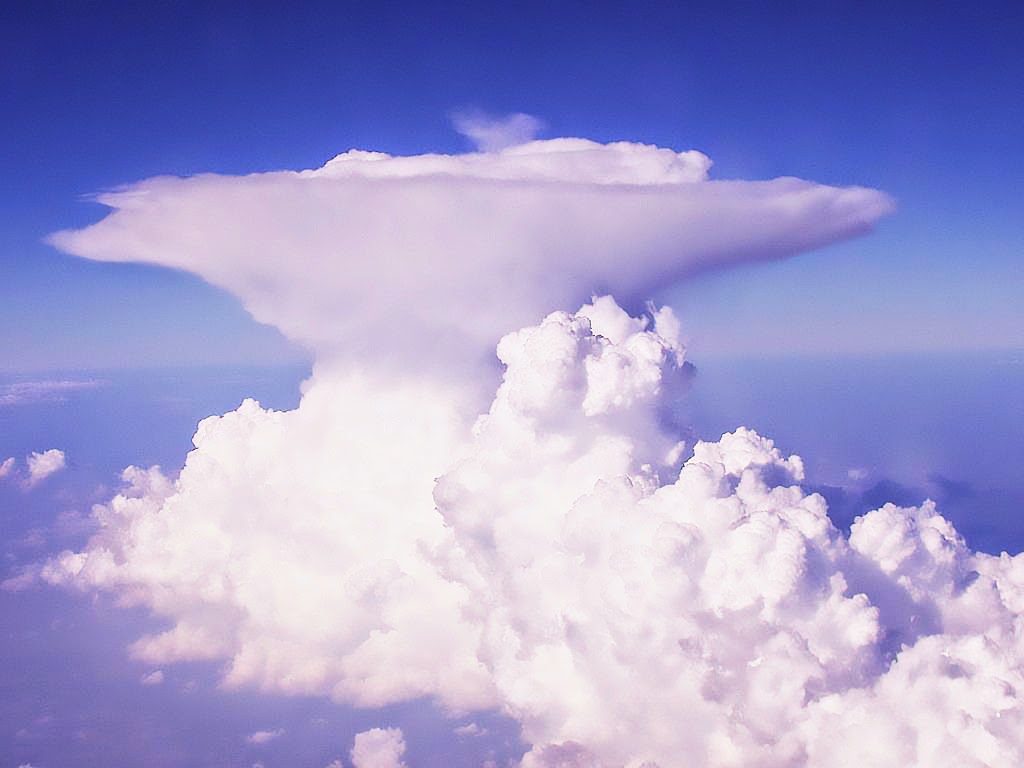
Cumulonimbus. This formation involves clouds developing as a very high column in
the sky, reaching up to 12 km in height. They have the typical anvil shape, where the upper tip
normally shows the direction of movement of the cloud formation. Compared to the other clouds, they
have a way bigger extent in height:
In fact, the Cumulonimbus is the only kind of cloud that can create its own wind in
any direction due to the strong convective air currents. This means that these clouds move
independently from the normal winds and become unpredictable and very unstable. The wind direction
and intensity can change dramatically and suddenly, just in few minutes, in the presence of these
stormy formations.
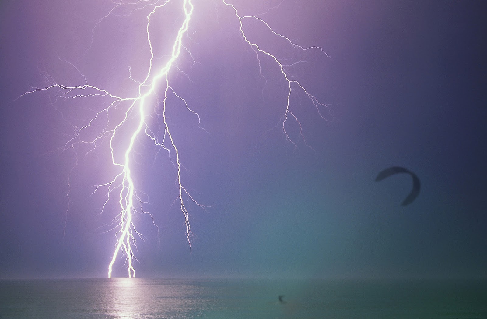
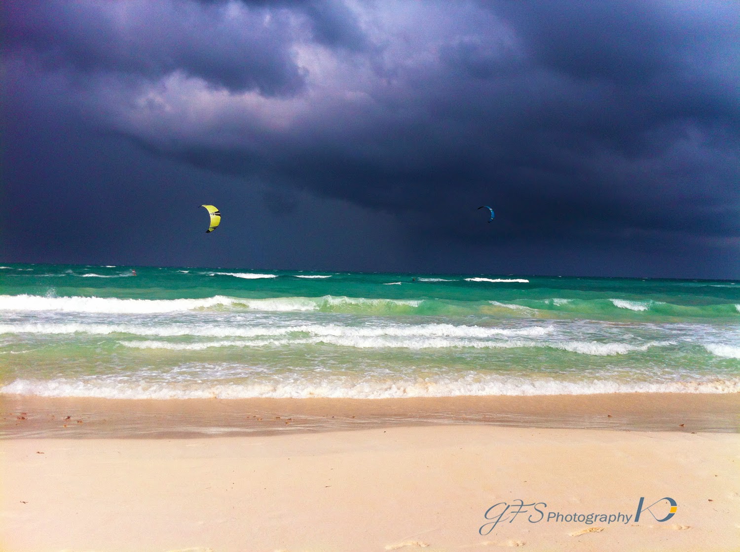
WARNING: When you see such a formation on the horizon, you'd better keep an eye on it and stop kitesurfing. In this case, you don't need 'meteo kitesurf' to decide to get out of the water at the first sign of its approach to your area.
The strong upward convective air currents can literally lift up a rider from the water surface in fractions of second with hazardous outcomes, while strong downward cold air currents generate unpredictable wind gusts in any direction. Not to talk about the lightning formation due to the rapid movement of ionized air masses of different temperatures and densities.
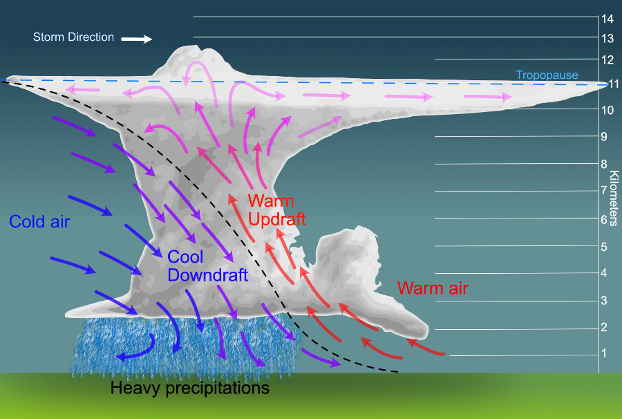
Another interesting phenomenon coming with the Cumulonimbus is the generation of microbursts of cold air, violently thrown to the ground with devastating effects.
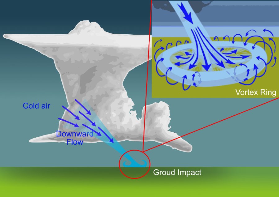
A microburst is created by a volume of strongly rain-cooled, descending air that, after hitting
ground level, spreads out in all directions producing strong winds. Inside the microbursts,
Vortex ring gusts can reach up to 170 mph (270 km/h). Imagine being captured in one of these
with your kite in the air!
So, let's see the sequence of a cold front approaching an area filled with warm air.
Meteorological sequence of a entering cold front:
|
|
Approaching front
|
Front passing over
|
Inside the cold front
|
|
Wind
|
Reinforces and changes direction close to the front
|
Abrupt changes with whirlwinds and gusts
|
Constant direction, strong and with gusts
|
|
Clouds
|
Sequence: Stratus and Cumulus, Nimbostratus
get thicker
|
Cumulonimbus
|
Clear with occasional Cumulus formations
|
|
Rain
|
Heavy, close to the front
|
Strong rain, with hail and lightnings
|
Normally light for 30 min, then rain showers |
|
Visibility
|
From moderate to poor, occasional fogs
|
Bad due to heavy rain
|
Very good
|
Of course, this is just a quick summary of how weather conditions can change and influence our kitesurfing experience and this post has no intention to be exhaustive or complete since we're not weather pros. The idea is to give some hints about how to read the weather when you are out in the water and make sure we won't find ourselves in a dangerous situation due to sudden weather changes.
Feel free to comment and give your own opinion and as usual! Safe kitesurfing!

Mouse pad
Logo: Riding the wind surfing the waves
Promote your Kite School for free!
Index your Kite School in our database.
You will get free lifetime visibility on Kitesurf Culture website.
If you have a website, it will provide precious backlinks to improve your SEO ranking
Relevant Posts

Effects of the air pressure, temperature and humidity in kitesurfing

3 Untold Wind Window Behaviors.
Where to Find Wind Year-Round: go kiting in the best Kitesurfing Spots

What's a Stall of a Kite and How to Prevent It
Kitesurf Line Length and Kite Behavior: Long or Short Lines?

12 Tips to Correctly and Safely Launch and Land Your Kite
Get free Kitesurfing Resources and Tips
If you like our content and you want to be informed on the next blogposts release, please subscribe here. That will also help us to continue to provide quality content:
Give us your opinion.
Mouse pad
Logo: Riding the wind surfing the waves
Promote your Kite School for free!
Index your Kite School in our database.
You will get free lifetime visibility on Kitesurf Culture website.
If you have a website, it will provide precious backlinks to improve your SEO ranking
Relevant Posts
Effects of the air pressure, temperature and humidity in kitesurfing
3 Untold Wind Window Behaviors.
Where to Find Wind Year-Round: go kiting in the best Kitesurfing Spots
What's a Stall of a Kite and How to Prevent It
Kitesurf Line Length and Kite Behavior: Long or Short Lines?
12 Tips to Correctly and Safely Launch and Land Your Kite
Toddler Premium T-Shirt

Logo: When life gives you wind go kiting
Latest Posts
Kitesurfing Dubai: an honest guide. Tips, Spots & Winds

Unwind and learn: best beginner kitesurfing spots worldwide

Self-Rescue in Kitesurfing: A Crucial Guide to Safety

Kitesurf Ometepe: an Epic Kite Trip to Nicaragua

Kitesurfing Spring in Andalucia: Unexpectedly Great!