Imagine yourself enjoying a great kitesurfing session when the weather suddenly starts changing. The wind feels different, some dark clouds appear on the horizon, and you are not quite sure what is coming. Is a storm approaching? Is the wind about to change direction or increase dramatically? Or are those just harmless clouds that won't affect your kitesurfing conditions at all?
Obviously, you don't want to interrupt your session just to get back to the beach and check windy, windfinder or windguru. Besides, even the best wind forecast cannot always tell you exactly what is happening above your head at that particular moment.
This is why learning to recognize weather patterns by observing the sky is an extremely useful skill for every kitesurfer.
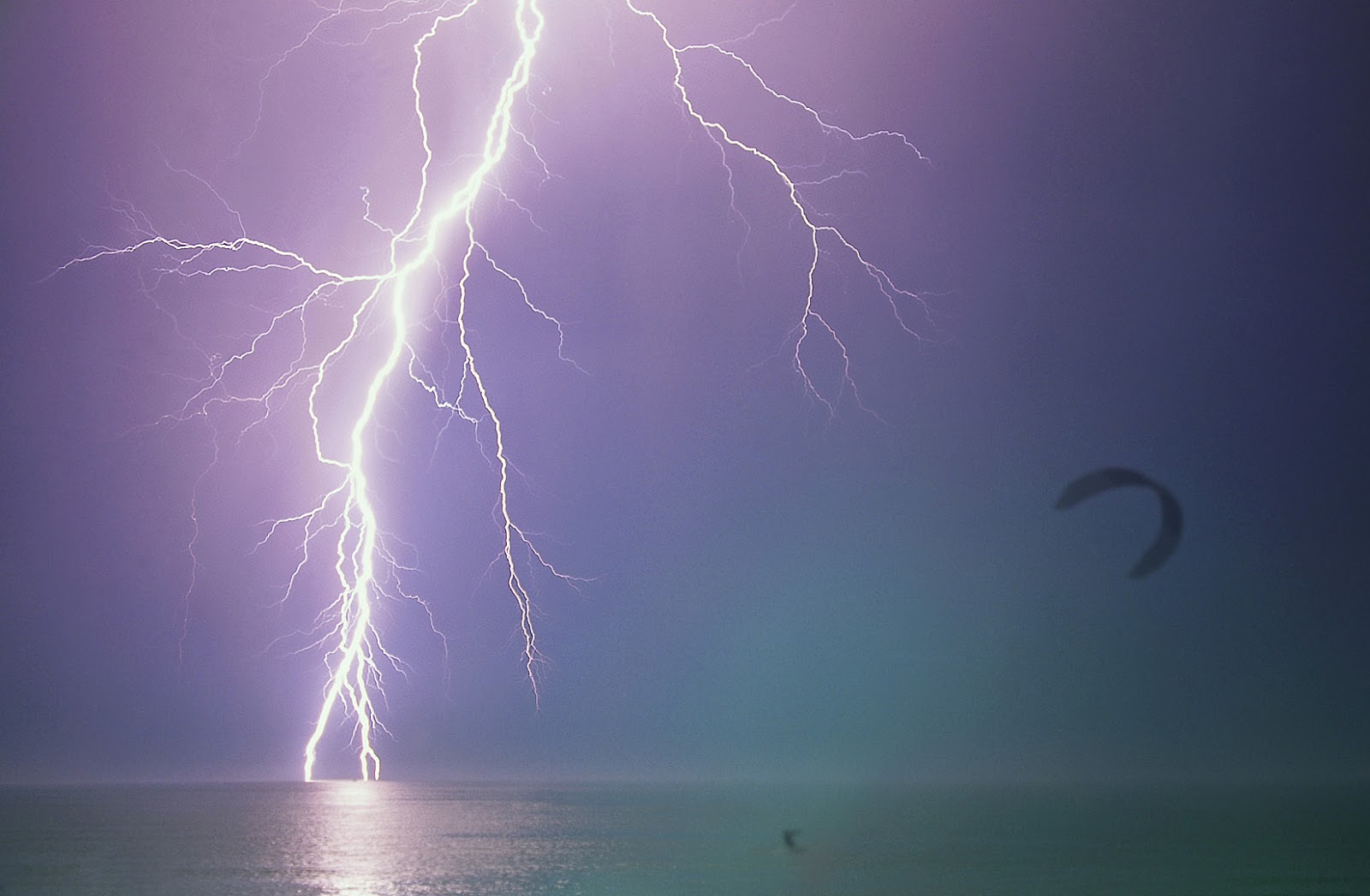
Kitesurfing, like all wind-based sports, is completely dependent on weather conditions. We spend plenty of time looking for the perfect wind forecast, but knowing when the wind will blow is only part of the story. Understanding when conditions might become dangerous is equally important.
So, let's see how wind is generated, what happens when different air masses meet, and how we can recognize the weather changes that might affect our next kitesurfing session.
Where does the wind come from?
Wind is basically moving air. The main cause of this movement is the difference in atmospheric pressure between different areas of the planet, largely resulting from the uneven heating of the Earth's surface by solar radiation.
Some areas become warmer than others, creating temperature and pressure differences that set enormous masses of air in motion.
In simple terms, air tends to move from areas of higher pressure toward areas of lower pressure. Of course, Earth's rotation, geography, and other factors influence the actual wind direction and speed, but the basic principle is relatively simple.
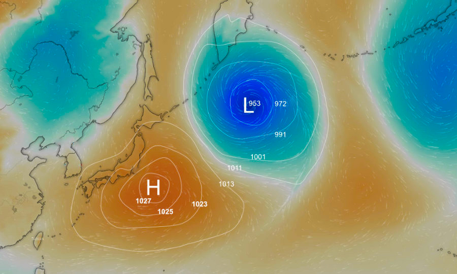
We could say that the sun is the engine behind the wind. It can generate it on a planetary scale, producing the prevailing winds we encounter in many famous kitesurfing destinations, or locally, due to particular geographical conditions.
In this second case, we often talk about thermal winds.
Thermal winds: when the sun creates our afternoon session
If you have ever been kitesurfing in a spot where the wind regularly picks up around midday, becomes stronger during the afternoon, and gradually disappears toward sunset, you have probably experienced a thermal wind.
During a sunny day, the land normally heats up faster than the sea. The warmer air above the land rises, and cooler air from above the water moves inland to replace it, creating what we call a sea breeze.
At higher altitudes, a return circulation completes the process.
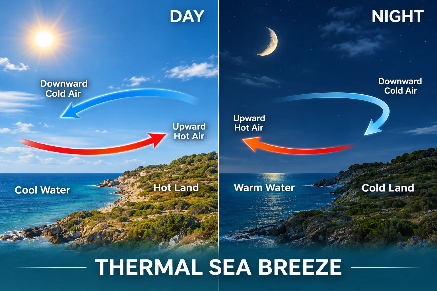
This is why certain kite spots enjoy remarkably consistent afternoon breezes, even when the general wind forecast is not particularly exciting.
However, thermal winds depend on temperature differences. When clouds cover the land, solar heating decreases, or a larger weather system approaches, our lovely afternoon breeze can weaken or disappear.
And that is precisely why understanding what happens in the sky becomes so useful.
Reading the sky: what clouds tell us about the weather
When conditions are stable, the wind is constant, the temperature remains relatively unchanged, and the sky is clear, we can generally enjoy our session expecting the weather to remain reasonably similar.
But when we notice changes in temperature, wind direction, or cloud formations, it is worth paying attention.
One of the main factors responsible for significant weather changes is the movement of different air masses, particularly when warm and cold air meet.
There are basically two situations:
A warm front, where warmer air advances over colder air.
A cold front, where colder air advances underneath warmer air.
To understand what happens, let's keep three simple facts in mind.
First, cold air is denser than warm air, so when the two meet, cold air tends to remain underneath, forcing the warmer air upward.
Second, warm air can hold more water vapor than cold air, although the actual humidity depends on the characteristics of each air mass.
Finally, when humid air rises, it expands and cools. If it cools sufficiently, water vapor condenses, producing clouds.
Depending on how quickly this process happens, we can experience anything from a gradual change in the weather to a violent thunderstorm.
1. Warm fronts: when the weather changes gradually
Let's start with the first situation: a warm front approaching an area occupied by colder air.
As shown in the illustration, when the warmer air reaches the colder air mass, it cannot simply push it away. Due to the difference in density, the warm air gradually slides above the cold air, rising along a relatively gentle slope.
As it rises, it cools, and the water vapor contained in it starts condensing, creating clouds.
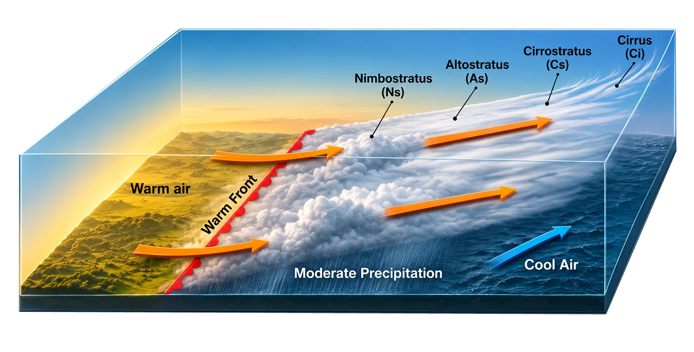
What makes this situation interesting is that clouds normally appear well before the warm front actually reaches us at ground level.
The typical sequence starts with high-altitude Cirrus, those thin, feather-like clouds that we often notice on otherwise clear days.
These are followed by Cirrostratus, forming a thin veil across the sky, sometimes producing a halo around the sun or moon.
As the front approaches, thicker Altostratus clouds begin to cover the sky, gradually hiding the sun.
Finally, Nimbostratus appear, often bringing widespread and continuous rain. Incidentally, nimbus is Latin for rain, which makes the name relatively easy to remember!
This sequence is usually quite slow. The first Cirrus clouds may appear even 24–36 hours before the arrival of significant precipitation, depending on how quickly the front is moving.
For kitesurfers, an approaching warm front often means a gradual change in wind strength and direction, increasing cloud cover, and eventually deteriorating visibility.
Typical weather sequence of an approaching warm front
|
|
Approaching front
|
Front passing over
|
Inside the warm front
|
|
Wind
|
Reinforces and changes direction
|
Abrupt changes
|
Constant direction
|
|
Clouds
|
Sequence of Cirrus, Cirrostratus, Altostratus, Nimbostratus and Stratus
|
Nimbostratus
|
Stratus and Stratocumulus
|
|
Rain
|
Heavy and continuous
|
Light or even stops
|
Occasional or light rain
|
|
Visibility
|
Gets worse as the rain becomes stronger
|
Bad
|
Limited with occasional fog formations
|
Of course, not every warm front follows exactly this sequence, and thunderstorms are also possible under certain conditions.
However, compared with an active cold front, the changes are generally more gradual, giving us more time to understand what is happening.
2. Cold fronts: when things become more interesting
The second situation is potentially much more dangerous for kitesurfers: a cold front advancing into an area occupied by warmer air.
Unlike the previous case, where warm air slides gradually over colder air, the advancing cold air behaves almost like a wedge, pushing underneath the warmer air and forcing it upward, often quite rapidly.
If the warm air contains sufficient humidity and the atmosphere is unstable, this movement produces strong upward convective currents and massive cloud formations.
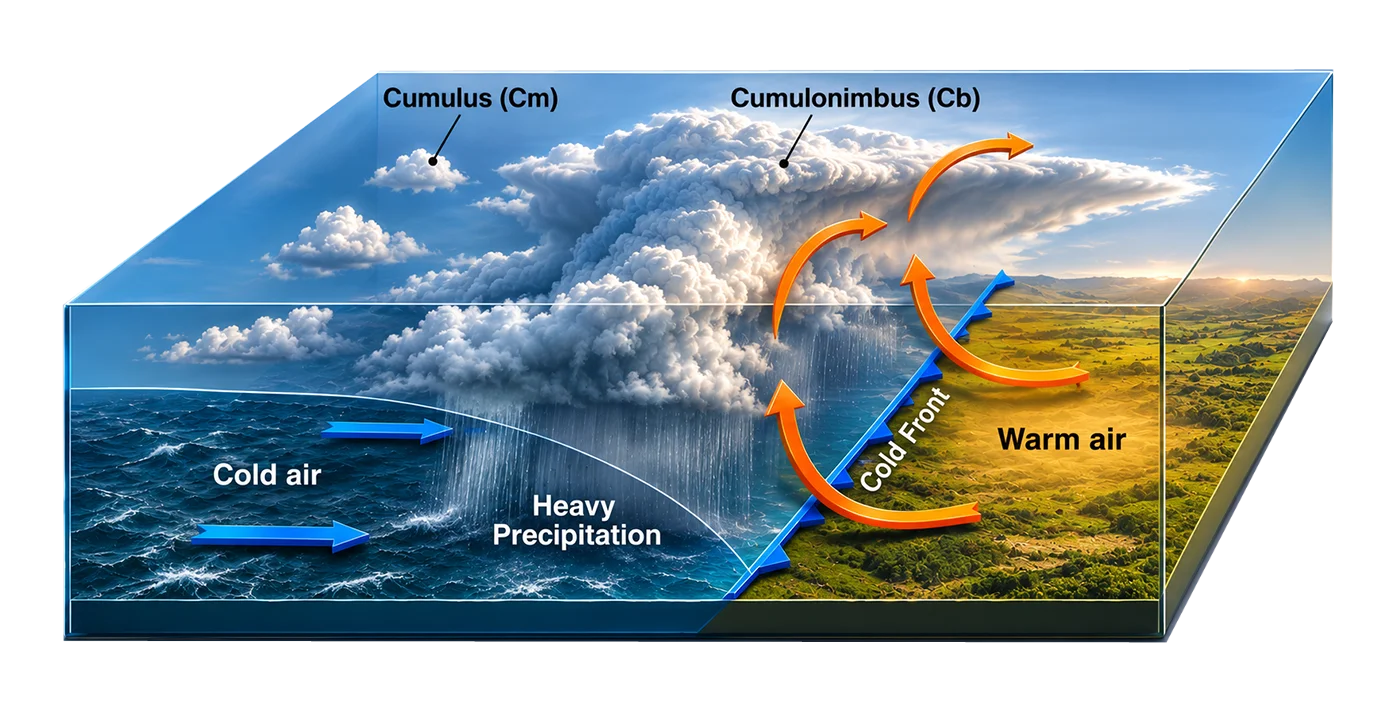
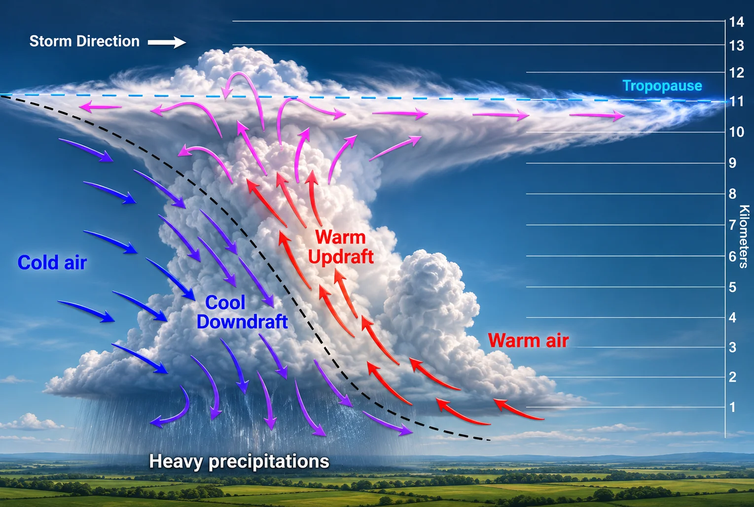
And this is where we can encounter one of the most dangerous cloud formations for anyone practicing a wind-based sport: the Cumulonimbus.
Cumulonimbus: the cloud every kitesurfer should recognize
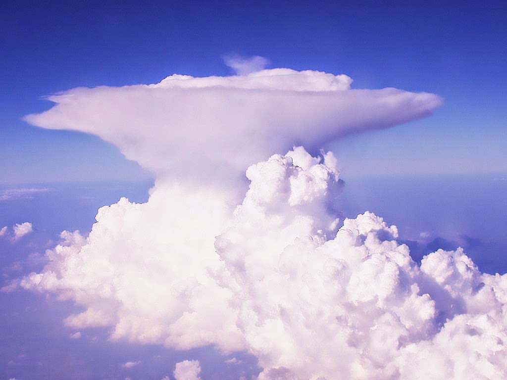
A Cumulonimbus is not just another dark cloud.
It is a huge vertically developed storm cloud that can reach 12 kilometers or more in height, depending on atmospheric conditions and geographical location.
It often has a characteristic anvil shape, with a massive vertical body and a flattened upper section spreading horizontally at high altitude.
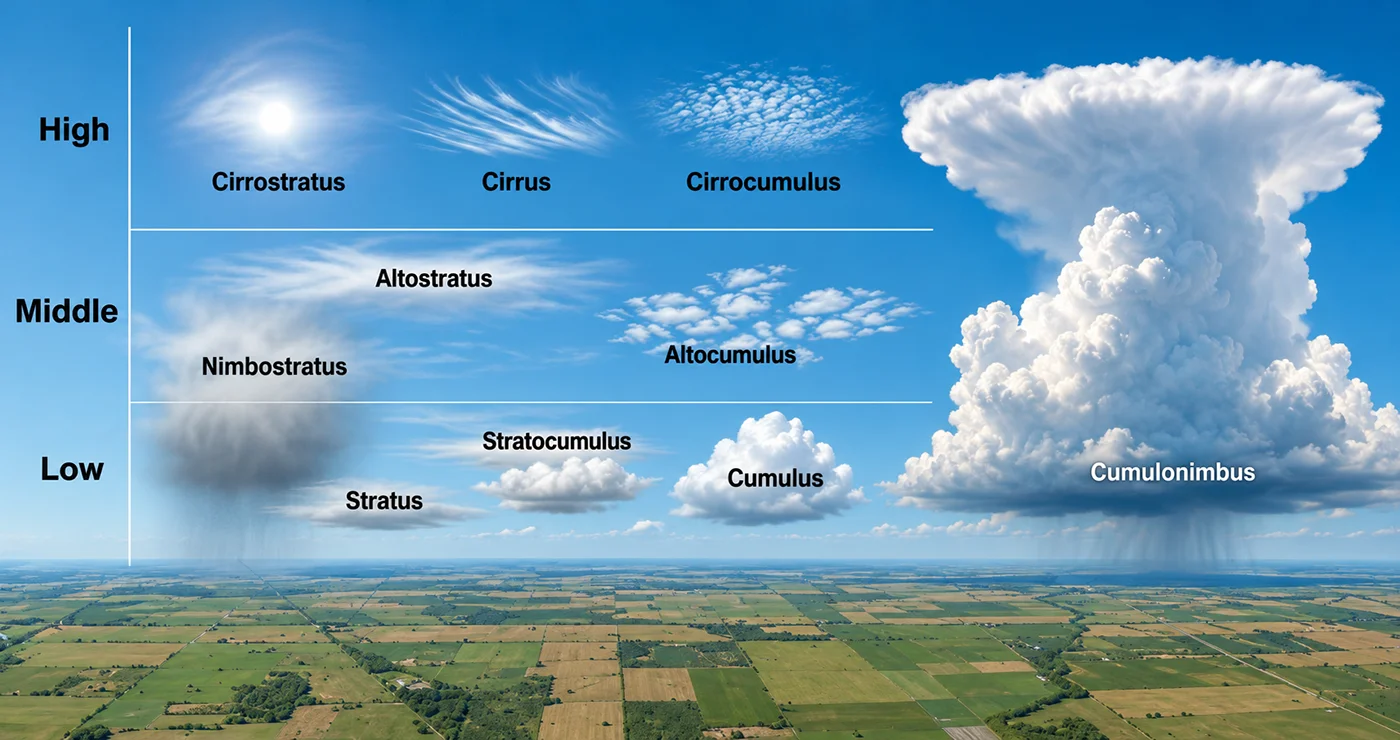
The upper anvil usually extends in the direction of the winds at that altitude, although the storm itself can follow a different path.
What makes these clouds particularly dangerous is the presence of powerful upward and downward air currents inside them.
Warm, humid air rises rapidly, while colder air descends, often accelerated by the cooling effect of evaporating precipitation. This circulation can generate heavy rain, hail, lightning, and extremely strong winds.
And here is the problem for us kitesurfers.
Although thunderstorms generally move with the surrounding atmospheric flow, the winds they generate close to the ground can be completely different from the prevailing wind.
Their speed and direction can change dramatically within minutes, sometimes even seconds.
Imagine kitesurfing comfortably with a steady 20-knot wind when a thunderstorm suddenly produces a powerful gust. Your perfectly manageable kite can become severely overpowered almost instantly.
The resulting force can drag or even loft a rider, with potentially disastrous consequences, particularly when close to the beach or other obstacles.
Then, of course, there is lightning.
Thunderstorms generate electrical discharges through the separation of electrical charges inside the clouds. Lightning can strike several kilometers away from the main rain area, sometimes even when the sky directly above us still looks relatively clear.
Being attached to a large kite on an open beach or in the water during a thunderstorm is certainly not a situation we want to experience!
WARNING: If you notice a towering Cumulonimbus developing or approaching your kitesurfing spot, don't wait for the wind to become dangerously gusty. Stop your session and get to safety before the storm arrives.
Microbursts: when the wind suddenly explodes
Another particularly dangerous phenomenon associated with thunderstorms is the formation of microbursts.
A microburst occurs when a concentrated volume of cold air descends rapidly from a storm cloud. Once this descending air reaches the ground or water surface, it spreads outward in all directions, generating extremely strong horizontal winds.
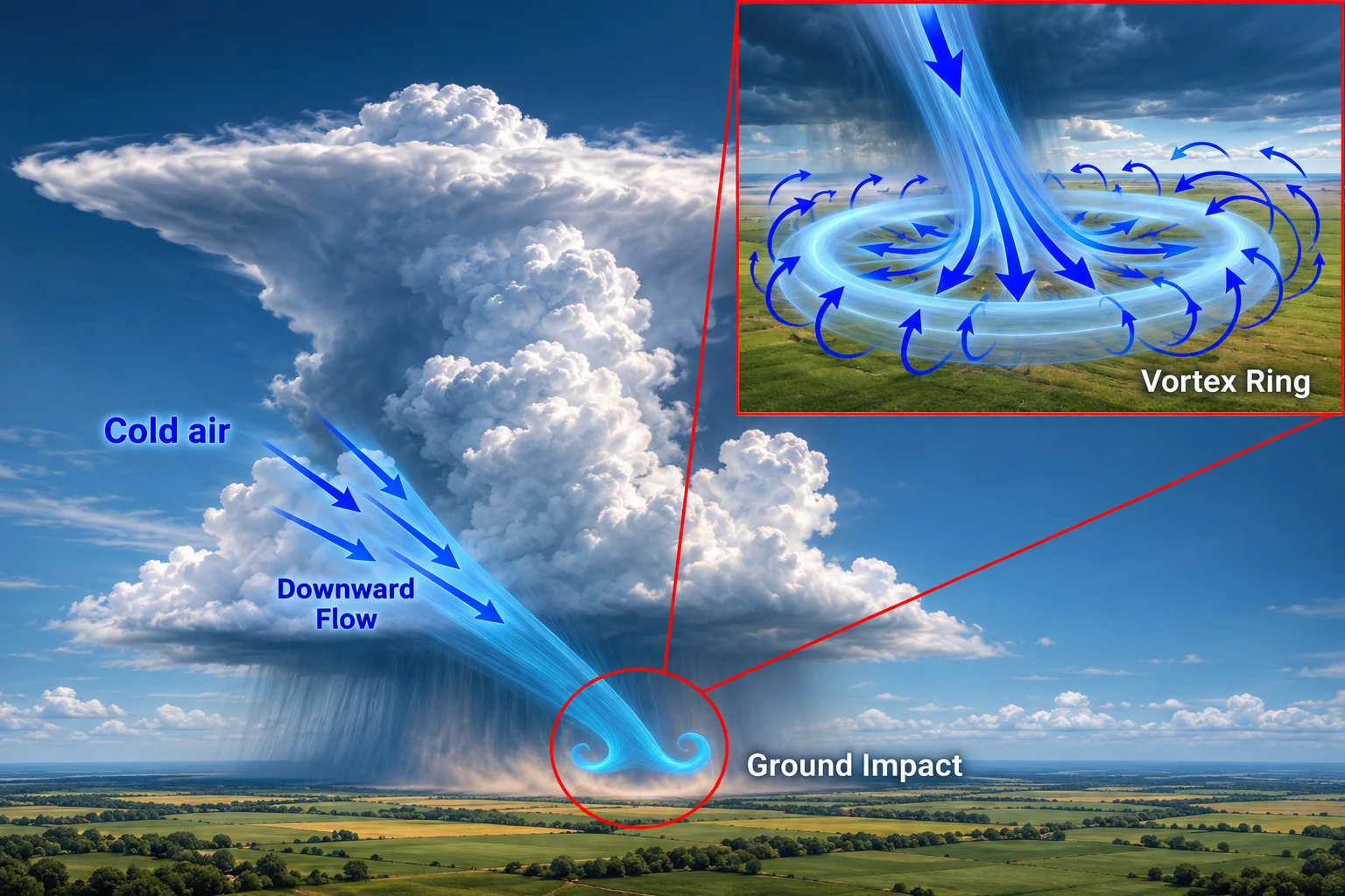
Imagine pouring a bucket of water onto a flat surface. The water hits the ground and spreads rapidly in every direction. A microburst behaves somewhat similarly, except that we are talking about a powerful mass of moving air.
Microbursts generally affect relatively small areas, often less than four kilometers across, and may last only a few minutes.
Nevertheless, their wind speeds can be extraordinary, occasionally exceeding 100 mph (160 km/h).
Imagine being caught in one of these with your kite flying!
Even more worrying is that the wind can suddenly change direction as the descending air spreads outward.
Closely related to this phenomenon are gust fronts, which form when cold air from a thunderstorm spreads horizontally ahead of the storm itself.
Sometimes we can recognize their approach by a sudden temperature drop, an abrupt change in wind direction, or a low, threatening shelf cloud moving across the horizon.
The gust front can reach us before the rain, which means that waiting for the first raindrops before deciding to land our kite is definitely not a good strategy.
Typical weather sequence of an approaching cold front
|
|
Approaching front
|
Front passing over
|
Inside the cold front
|
|
Wind
|
Reinforces and changes direction close to the front
|
Abrupt changes with whirlwinds and gusts
|
Constant direction, strong and with gusts
|
|
Clouds
|
Sequence: Stratus and Cumulus, Nimbostratus get thicker
|
Cumulonimbus
|
Clear with occasional Cumulus formations
|
|
Rain
|
Heavy, close to the front
|
Strong rain, with hail and lightnings
|
Normally light for 30 min, then rain showers |
|
Visibility
|
From moderate to poor, occasional fogs
|
Bad due to heavy rain
|
Very good
|
Naturally, not every cold front generates thunderstorms. Some pass through with relatively modest changes in the weather.
Likewise, thunderstorms don't necessarily require a cold front. They can also develop locally on hot, humid afternoons, particularly in tropical regions.
This is why recognizing cloud development is often more useful than simply knowing that a front is approaching.
What should we look for while kitesurfing?
So far, we have discussed the theory. But what does all this mean when we are actually out on the water?
Here are a few practical signs worth recognizing.
Clouds developing rapidly upward. Small Cumulus clouds are usually harmless, but when they start growing into huge, towering formations with dark bases, it may indicate developing thunderstorms.
Sudden changes in wind direction. Gradual changes can be perfectly normal, especially with thermal winds. Abrupt shifts, particularly when accompanied by strong gusts, deserve much more attention.
A noticeable temperature drop. A sudden cold breeze on an otherwise warm afternoon can indicate the arrival of cold outflow from a nearby storm.
Dark clouds and approaching rain curtains. A dark sky alone does not necessarily mean dangerous weather, but rapidly approaching storm clouds, shelf clouds, or intense precipitation are warning signs.
Thunder or lightning. This should be obvious, but it is worth repeating: if you hear thunder, the storm is already close enough to be dangerous. You should be off the water and in proper shelter.
None of these signs should be considered in isolation. What matters is recognizing how the conditions are evolving.
And remember, a thunderstorm can produce dangerous winds well before the rain reaches your beach.
Weather forecasts are essential, but don't forget to look at the sky
Nowadays, we have access to incredibly sophisticated weather forecasting tools.
Windy, Windfinder, Windguru, weather radar, and satellite imagery provide us with information that sailors and windsurfers could only dream about a few decades ago.
And obviously, checking a reliable forecast before starting a session remains essential.
Nevertheless, no forecast can guarantee exactly how local weather conditions will develop, particularly when thunderstorms and strong convective activity are involved.
This is why I believe that every kitesurfer should develop at least a basic understanding of the weather.
Before launching, check not only the expected wind speed but also the possibility of thunderstorms, sudden gusts, and major changes in wind direction.
And once you are in the water, keep looking around.
If a thunderstorm is approaching, return to shore while conditions are still manageable, land your kite safely, and seek shelter in a substantial building or a fully enclosed vehicle. Wait at least 30 minutes after the last thunder before returning outside.
After all, knowing when not to kitesurf is just as important as knowing how to kitesurf.
Final thoughts
Of course, this is just a simplified introduction to how weather conditions develop and influence our kitesurfing sessions. Meteorology is a complex subject, and this article certainly has no ambition to turn us into professional weather forecasters.
The idea is simply to give you a few useful hints about how to read the sky, recognize the most common weather patterns, and avoid finding yourself in a dangerous situation because of sudden weather changes.
Next time you are waiting for the wind to pick up, take a moment to look at the clouds. Try to recognize their shapes, observe how they evolve, and compare what you see with the forecast.
You might be surprised by how much information is right there above your head.
And if the sky starts looking threatening while you are kitesurfing, remember that there will always be another windy day.
Feel free to comment, share your experiences with unexpected weather changes, or add your own observations.
And, as usual, safe kitesurfing